The 2014 World Cup extravaganza in Brazil has been replete with stellar sportsmanship and stunning spectacle. However, let’s take a look at the stadiums themselves, hosting hundreds of thousands of people throughout the month-long World Cup. Are they as good as the games on the field?
Last week we wrote about how brilliantly Fenway Park is interwoven into Boston’s urban fabric — a post we called“Baseball Urbanism”.
This week we venture into “World Cup Urbanism.” Not that all sports arenas should look or operate like Fenway Park, but can design trends be detected, and lessons learned, from evaluating Brazil’s World Cup stadiums? Does each facility contribute to its host city’s urban fabric in a way that generates a new brand of World Cup Urbanism?
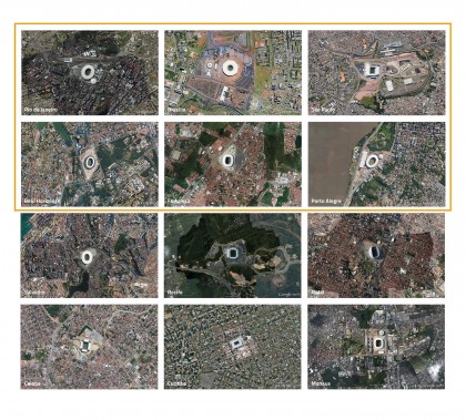
Allowing you to be the judge of that, we have compiled satellite images of all twelve of Brazil’s 2014 World Cup stadiums, superimposing a 1,200-foot grid onto each image to provide a scale for you to see throughout the photos. The stadiums are shown, along with their surrounding contexts, neighborhoods, parks, highways, railways and public transit stations.
As you view these images, consider how well the stadiums contribute to the urban fabric of their respective host cities. Does a strong spatial relationship exist between the arenas and their surrounding neighborhoods? Are pleasant public spaces created around the stadiums proper? Is the motion of pedestrian and vehicular traffic in and around the structure clear? How does public transportation, whether by bus or train, fit into the stadium’s design scheme? And, finally, is there a lasting economic benefit to fitting a massive sports arena into the fabric of a major city?

Estádio do Maracanã, Rio de Janeiro, Brazil (capacity: 78,838)
Maracanã is rich in soccer and architecture history. Besides being the host site of the 1950 World Cup Finals loss to Uruguay, the stadium’s architectural scale and ambition is an emblem of Brazil’s optimism for the future. It is commonly called Maracanã Stadium (Estádio do Maracanã, or its real name, Estádio Jornalista Mário Filho).
Note the massive access ramps at opposite ends of the structure — an architectural homage to Le Corbusier, the legendary modernist architect who visited Brazil in 1929. Corbu’s influence on Brazil’s contemporary architecture was extensive, and can be seen in the work of Oscar Niemeyer, the designer of many classic modernist masterpieces such as the major government buildings of Brasília, dedicated as Brazil’s new capital in 1960.
Note the stadium’s adjacency to a major two-lane highway and several public transportation depots. A corridor of ramps provides an access way into the arena, which is situated amid a heavily urbanized part of Rio.
Facts about Estádio do Maracanã and Rio de Janeiro, Brazil
• The stadium is named after famous sports journalist Mario Filho. The real stadium title is Estádio Jornalista Mário Filho.
• It opened June 16, 1950, and was renovated in 2000, 2006 and 2013.
• It is Brazil’s largest sports arena, with 78,838 seats and a field measuring 344 ft. × 223 ft.
• Brazil lost to Uruguay 2-1 in this stadium in the final game of the 1950 World Cup.
• Estimated attendance at the 1950 World Cup final game on July 16, 1950, was 199,854.
• Estádio do Maracanã will also host the opening and closing ceremonies of the 2016 Summer Olympics and the 2016 Summer Paralympics.
• The stadium has hosted concerts by Tina Turner, Frank Sinatra, Kiss, Iron Maiden, and Paul McCartney.
• 6.3 million people live in Rio de Janeiro.
• Rio is Brazil’s second largest city, founded in 1565, known for its Christ the Redeemer statue.
• Rio is one of the most visited cities in the southern hemisphere.
• “Rio de Janeiro” means “River of January” in English translation — but this is a misnomer, as no river runs through Rio.
• Rio de Janeiro was Brazil’s capital until 1960, when Brasília took its place.

Estádio Nacional Mané Garrincha, Brasilia, Brazil (capacity: 69,432)
Brasília, Brazil’s capital city, was completed and dedicated on April 21, 1960. It is situated in the middle of a heavily forested region of Central Brazil. This city is full of utopian ambition. It is a symbol of Brazil’s fearless pursuit of a better future, but also a clear attempt to reach into the depths of Brazil’s vast resources and potential.
Lúcio Costa, the city’s planner, laid out Brasília as a system of interrelated superblocks linked by highways and infrastructure. The city’s cross-spine houses involve all of the civic and governmental offices and monuments. The overall city plan resembles the outline a futuristic jet landing in the middle of a forest.
Likewise, the city’s stadium, Estádio Nacional Mané Garrincha, appears as if it landed on the site without regard to its surroundings. In many ways, it could be anywhere in Brazil. There are few clues about its special locus. Nevertheless, it does appear to be well planned. The circular plan is fitted with ample parking.
Facts about Estádio Nacional Mané Garrincha in Brasilia, Brazil
• The stadium was named after Mané Garrincha, who won the World Cup with Brazil in 1958 and 1962.
• It opened in 1974 and was reconstructed in 2010-2013.
• It is Brazil’s second largest sports arena, with 69,432 seats.
• Three-year renovations of the stadium cost Brazil $900 million in US dollars.
• Brasília is Brazil’s fourth largest city, with a population of almost 3 million.
• Brasília is the capital of Brazil, after it was passed on from Rio de Janeiro in 1960.
• Brasília’s illiteracy rate is only 4.35%.

Arena Corinthians, São Paulo, Brazil (capacity: 63,321)
São Paulo, Brazil’s largest city, boasts the newly dubbed Arena de São Paulo, or Arena Corinthians, home to a 66,200-seat fútbol stadium. The relationship between the stadium and its surrounding context is tenuous at best. The highways resemble the tentacles of an octopus in the way they wrap around the arena and its surrounding parking structure.
More promising, however, is the stadium’s proximity to Red Line Metro 3 and Arthur Alvin Station, 900 meters from the facility, which enables large crowds to attend matches via public transportation. A number of major highway routes surround the arena. As the largest city in Brazil, São Paulo does have limited parking, which the public transit system helps to alleviate. The stadium also does sit a bit awkwardly in-between the tentacle-like infrastructure.
Facts about Arena de São Paulo in Sao Paulo, Brazil
• During the FIFA World Cup 2014, the stadium was called Arena de São Paulo due to FIFA obligations, but is widely known as Arena Corinthians.
• The arena re-opened May 10, 2014.
• It will be used again for the 2016 Brazil Olympics in Rio de Janeiro.
• It is owned and operated by Sport Club Corinthians Paulista, São Paulo’s professional soccer team.
• The arena has 17,000 temporary seats only for FIFA World Cup, but these will be removed after the event.
• The stadium has a normal seating capacity of 48,234.
• São Paulo is the largest city in Brazil.
• São Paulo is the home of the São Paulo Stock Exchange (BM&F Bovespa).
• São Paulo is known for its unreliable, rapidly changing weather, being situated in a monsoon-influenced humid subtropical climate.
• São Paulo was founded in 1554.
• São Paulo is located on the mid-east coast of Brazil.

Estadio Mineirão, Belo Horizonte, Brazil (capacity: 62,170)
Geometry reigns supreme in Belo Horizonte. A diamond-shaped public platform houses the oval-shaped stadium, Estadio Mineirão (officially Estádio Governador Magalhães Pinto, or Governor Magalhães Pinto Stadium). The relationship between the stadium grounds and their surrounding context is more accidental then intentional. Positioned next to a small dense forest, the arena’s layout is oddly positioned in relation to the rest of the overall site.
Each side of the platform abuts a different landscape: one side is a mix of urban uses, the other is raw forest. Pedestrian and vehicular ramps feed the stadium complex in awkward relationships, despite the architectural prowess of the modern day arena; the resultant urban fabric is contorted.
Facts about Estadio Mineirão in Belo Horizonte, Brazil
• Construction started in 1959.
• The arena will host some matches in the 2016 Brazilian Summer Olympics.
• Belo Horizonte means “Beautiful Horizon.”
• Belo Horizonte is located in Brazil’s northeastern region.
• The city’s population is 2.5 million.
• First settled in 1701, the City of Belo Horizonte was planned and built in the 1890s.
• It is located 190 miles from the closest beach.
• The city has a noticeable Italian influence in its cuisine, dance and architecture.
• It hosts many multinational corporations, such as Google and Amazon.
• In addition to the 2014 FIFA World Cup, Belo Horizonte hosted the 2013 FIFA Confederations Cup and the 1950 FIFA World Cup.

Estadio Castelão, Fortaleza, Brazil (capacity: 58,400)
Located in northeastern Brazil, Fortaleza is home to a renovated stadium, first built in 1973. The structure sits on an expansive platform, and half of the site is dedicated for parking. The area demarcating the “stadium zone” is clearly defined, almost like a fortress, set within dense neighborhoods.
The neighborhoods are clustered closely to its perimeter. With the exception of the green pitch of the soccer field, few other green surfaces exist within the stadium grounds in this otherwise lush city environment. However, there is a neatly defined order to the site — more Teutonic than Samba. With the adjacent neighborhoods surrounding the stadium on three out of four sides, one can speculate on how loud the arena gets during the middle of a game, and its impact on the neighborhoods.
Facts about Estadio Castelão in Fortaleza, Brazil
• Estadio Castelão was first built in 1973 and holds a maximum of 67,073 people.
• It is the home of Ceara Sporting Club.
• It was last renovated in 2001 by Uruguayan architect Héctor Vigliecca — a Brazilian citizen since 1975 — with two double tiers below for 8,300 parking spots.
• It is located in Northeastern Brazil amid a population of 2.55 million.
• Fortaleza is the fifth largest city in Brazil.
• Founded in 1500 by Spanish Conquistadores, Fortaleza means “Fort of Our Lady of the Rising.”
• Its warmest month of the year is January, with an average high of 87°F.

Estadio Beira-Rio, Porto Alegre, Brazil (capacity: 43,394)
Estadio Beira-Rio (Riverside Stadium), officially Estádio José Pinheiro Borda, is a waterfront arena that presents special civic opportunities for Porto Alegre. Nestled between highways and roadways along the Guaíba River, the structure sits within a mix of urban and open spaces. The question, then, is: How well connected is the stadium to the waterfront for pedestrians? With no noticeable public transportation other than buses on roads, how convenient is the location of this arena?
The large lake seen on the satellite images provide a context for where the stadium is placed outside the city center. The arena pulls traffic outside of the city center toward the outskirts for events. Porto Alegre’s waterfront site is similar in ways to those of stadiums in the US, e.g., San Francisco’s AT&T Park.
Facts about Estadio Beira-Rio in Porto Alegre, Brazil.
• It is the second largest stadium in Southern Brazil.
• It opened in 1969 when Sport Club Internacional beat Portugal 2-1.
• It has an outside parking venue for 3,000 cars.
• It is one of the only FIFA World Cup stadiums to be privately owned.
• Porto Alegre means “Joyful Harbor.” It was founded in 1769 by Manuel Sepulveda.
• Porto Alegre has 1.5 million inhabitants and a broad-based local economy surrounded by agriculture and produce production.
• The city is located in the southern region of Brazil.
Final Thoughts
For all of the excitement associated with the World Cup and its preparations, the massive investment of over $11 billion into stadium construction throughout Brazil, has been a source of major social and political strife in Brazil. Important questions about how much should be invested in “games” vs. education, public services, transit and other primary public interests must be addressed. For this reason, the design of the stadiums and their relationships to the urban fabric of their host cities must be well considered. Can these structures and the range of uses they support evolve over time so they can generate more social, educational and economic benefits to local and regional economies?
Stay tuned for Part II
By Paul Lukez, Cam King, Matt Uminski and Todd Larson